Navigating Space Junk
Navigating Space Junk
A new mapping technique aims to help spacecraft avoid collisions with debris and other vessels between Earth and the moon.
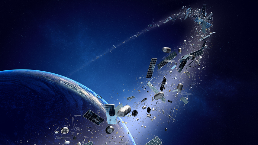
Cislunar space—the 238,900-mile region between Earth and its moon—is vast, but not infinite. And it’s getting crowded.
Some 130 million pieces of debris from satellites and vehicles have collected in this area as well as near-Earth orbit, which extends a much tighter 24,000 miles from the planet’s surface.
Space trash may be out of sight for humans on terra firma, but it poses literally millions of obstacles for an estimated $30-billion industry expected to take off within the next two decades. Dozens of missions will be launched for government, telecommunications, and other industries. Spacecraft could not only run into this deritus, but also one another.
Purdue University engineer Carolin Frueh, an aeronautics and astronautics professor, is working to reduce the risk of such collisions with a mapping technique to create “visibility maps.” These maps will overcome previous methods’ limits, keep up with changes in cislunar traffic, and can “evolve over time,” Frueh said. This will determine the best regions that telescopes should use to find and track human-made objects in cislunar space.
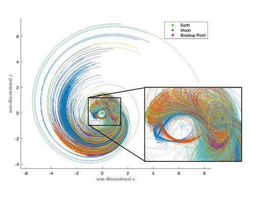 Exploded spacecraft fragments could disperse millions of miles away. Each colored line indicates how far fragments could spread in 30 days from one explosion point on Lyapunov orbit around the second Lagrange point. Credit: Purdue University image/Ariel Black/Carolin Frueh
Surabhi Bhadauria, a Purdue Ph.D. candidate, teaching assistant, and Frueh’s research assistant, added that while space missions have shifted their focus to returning to the moon, Frueh and the team hoped to answer questions such as: How does space debris move farther from the Earth? From where can we see it? What are the limiting constraints that govern the visibility of space objects?
Exploded spacecraft fragments could disperse millions of miles away. Each colored line indicates how far fragments could spread in 30 days from one explosion point on Lyapunov orbit around the second Lagrange point. Credit: Purdue University image/Ariel Black/Carolin Frueh
Surabhi Bhadauria, a Purdue Ph.D. candidate, teaching assistant, and Frueh’s research assistant, added that while space missions have shifted their focus to returning to the moon, Frueh and the team hoped to answer questions such as: How does space debris move farther from the Earth? From where can we see it? What are the limiting constraints that govern the visibility of space objects?
The movements of the Earth and moon, and where they’re located in relation to the sun, are constantly changing. Previous mapping methods had to re-run a model for each condition that would affect a telescope’s orbit and overall viewing geometry at each instance in time, requiring constant recalculations, which themselves are intensive.
Frueh’s team hoped to create a technique that was much faster and didn’t need additional computations for each variable. What makes their visibility maps able to do so? They allow for seeing more of a region by averaging out all the orbits a telescope might use, rather than integrating each orbit change over time.
“The parameter space is vast, so a global or near-global optimization for observations or of a mission profile for visibility was not possible,” Frueh said. “We were motivated to provide better solutions and steer away from single-point solutions and high computational demands.”
Become a Member: How to Join ASME
Bhadauria said the method “is more focused on where to look from rather than what to look at.” The maps allow researchers to look at the entire cislunar space to find the “sweet spots” for the surveillance scenario, offering better visibility of cislunar space.
“In our models, the Earth, the moon, the objects of interest, and our sensors are moving according to the underlying astrodynamics,” Frueh said. “We use a simplification, the bicircular restricted four-body problem, for fast computation, and a high-fidelity ephemerides model for validation and refinement.”
When producing the maps, the team was able to provide an overview of cislunar space visibility for a given time frame without the need to select specific targets, added Bhadauria. Through the use of bicircular four body geometry, researchers could study the repeated behavior of the main bodies—the Earth, moon, sun, and debris—that influence visibility. “We are also working towards incorporating more limiting constraints to make our model more accurate,” she said.
All this can be used to help space vehicles, crewed or uncrewed, travel safer.
 Human-made space objects as cataloged by the U.S. Space Force. Red objects are in near-Earth orbits. Green objects are in the cislunar region. Credit: Purdue University image/Carolin Frueh
“Operational vehicles can make avoidance maneuvers if a collision is predicted in a timely manner. Therefore, we need good observations and orbit determination on all vehicles independent of an active line of communication to have overall space situational awareness,” Frueh said. “Space debris, on the other hand, is, per definition, not able to maneuver. If we take the near-Earth situation as an indicator of the evolution of object population in cislunar, there will most likely be more debris objects than active missions.”
Human-made space objects as cataloged by the U.S. Space Force. Red objects are in near-Earth orbits. Green objects are in the cislunar region. Credit: Purdue University image/Carolin Frueh
“Operational vehicles can make avoidance maneuvers if a collision is predicted in a timely manner. Therefore, we need good observations and orbit determination on all vehicles independent of an active line of communication to have overall space situational awareness,” Frueh said. “Space debris, on the other hand, is, per definition, not able to maneuver. If we take the near-Earth situation as an indicator of the evolution of object population in cislunar, there will most likely be more debris objects than active missions.”
The Purdue team’s work might also be applicable to the problem of space garbage that has accumulated in Earth’s near-orbit but is moving further away. A rogue rocket booster even crashed into the lunar surface in March 2022.
“The mapping per se will only help to track objects in cislunar space, which is a precursor for predicting collisions in a timely manner and having awareness of the situation of all objects, missions, and space debris alike. It can hence be a piece in a larger effort to reduce space debris,” Frueh says. “Most importantly, we need to avoid the creation of space debris in the first place, via missions that are planned with the problem of space debris in mind, passivation of upper stages, proper end-of-life measures, and active collision avoidance while on orbit.”
Eydie Cubarrubia is an independent writer in New York City.
Some 130 million pieces of debris from satellites and vehicles have collected in this area as well as near-Earth orbit, which extends a much tighter 24,000 miles from the planet’s surface.
Space trash may be out of sight for humans on terra firma, but it poses literally millions of obstacles for an estimated $30-billion industry expected to take off within the next two decades. Dozens of missions will be launched for government, telecommunications, and other industries. Spacecraft could not only run into this deritus, but also one another.
Purdue University engineer Carolin Frueh, an aeronautics and astronautics professor, is working to reduce the risk of such collisions with a mapping technique to create “visibility maps.” These maps will overcome previous methods’ limits, keep up with changes in cislunar traffic, and can “evolve over time,” Frueh said. This will determine the best regions that telescopes should use to find and track human-made objects in cislunar space.
Exploded spacecraft fragments could disperse millions of miles away. Each colored line indicates how far fragments could spread in 30 days from one explosion point on Lyapunov orbit around the second Lagrange point. Credit: Purdue University image/Ariel Black/Carolin Frueh
The movements of the Earth and moon, and where they’re located in relation to the sun, are constantly changing. Previous mapping methods had to re-run a model for each condition that would affect a telescope’s orbit and overall viewing geometry at each instance in time, requiring constant recalculations, which themselves are intensive.
Frueh’s team hoped to create a technique that was much faster and didn’t need additional computations for each variable. What makes their visibility maps able to do so? They allow for seeing more of a region by averaging out all the orbits a telescope might use, rather than integrating each orbit change over time.
“The parameter space is vast, so a global or near-global optimization for observations or of a mission profile for visibility was not possible,” Frueh said. “We were motivated to provide better solutions and steer away from single-point solutions and high computational demands.”
Become a Member: How to Join ASME
Bhadauria said the method “is more focused on where to look from rather than what to look at.” The maps allow researchers to look at the entire cislunar space to find the “sweet spots” for the surveillance scenario, offering better visibility of cislunar space.
“In our models, the Earth, the moon, the objects of interest, and our sensors are moving according to the underlying astrodynamics,” Frueh said. “We use a simplification, the bicircular restricted four-body problem, for fast computation, and a high-fidelity ephemerides model for validation and refinement.”
When producing the maps, the team was able to provide an overview of cislunar space visibility for a given time frame without the need to select specific targets, added Bhadauria. Through the use of bicircular four body geometry, researchers could study the repeated behavior of the main bodies—the Earth, moon, sun, and debris—that influence visibility. “We are also working towards incorporating more limiting constraints to make our model more accurate,” she said.
All this can be used to help space vehicles, crewed or uncrewed, travel safer.
Human-made space objects as cataloged by the U.S. Space Force. Red objects are in near-Earth orbits. Green objects are in the cislunar region. Credit: Purdue University image/Carolin Frueh
The Purdue team’s work might also be applicable to the problem of space garbage that has accumulated in Earth’s near-orbit but is moving further away. A rogue rocket booster even crashed into the lunar surface in March 2022.
“The mapping per se will only help to track objects in cislunar space, which is a precursor for predicting collisions in a timely manner and having awareness of the situation of all objects, missions, and space debris alike. It can hence be a piece in a larger effort to reduce space debris,” Frueh says. “Most importantly, we need to avoid the creation of space debris in the first place, via missions that are planned with the problem of space debris in mind, passivation of upper stages, proper end-of-life measures, and active collision avoidance while on orbit.”
Eydie Cubarrubia is an independent writer in New York City.
Related Content

5 Feedstocks for Biomass Energy Production
Apr 25, 2024
Wood, corn, even dung can heat homes and power industry. Discover energy from biomass.

ChatGPT Proves Smart as an Engineer, Promise as Teaching Tool
Apr 24, 2024
Researchers found that ChatGPT could pass the licensed engineer exam while exploring how AI could facilitate learning and teaching.
Wearable Patch Offers Voice to the Voiceless
Apr 18, 2024
A thin self-powered patch can sense the movement of laryngeal muscles and translate those movements into audible speech.

Energy Blog: Noticeable Eclipse Impact on Electricity Sector
Apr 17, 2024