Infographic: Hopes Remain High as Drone Usage Grows
Infographic: Hopes Remain High as Drone Usage Grows

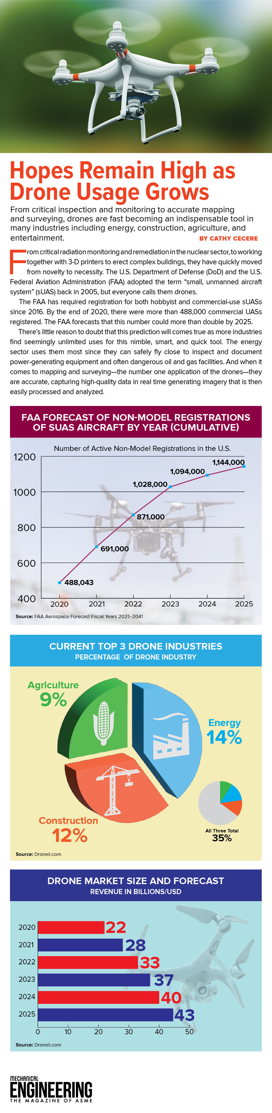
From critical inspection and monitoring to accurate mapping and surveying, drones are fast becoming an indispensable tool in many industries.
From critical radiation monitoring and remediation in the nuclear sector, to working together with 3-D printers to erect complex buildings, they have quickly moved from novelty to necessity. The U.S. Department of Defense (DoD) and the U.S. Federal Aviation Administration (FAA) adopted the term "small, unmanned aircraft system" (sUAS) back in 2005, but everyone calls them drones.
The FAA has required registration for both hobbyist and commercial-use sUASs since 2016.
By the end of 2020, there were more than 488,000 commercial UASs registered. The FAA forecasts that this number could more than double by 2025.
There's little reason to doubt that this prediction will comes true as more industries find seemingly unlimited uses for this nimble, smart, and quick tool. The energy sector uses them most since they can safely fly close to inspect and document power-generating equipment and often dangerous oil and gas facilities. And when it comes to mapping and surveying—the number one application of the drones—they are accurate, capturing high-quality data in real time generating imagery that is then easily processed and analyzed.
From critical inspection and monitoring to accurate mapping and surveying, drones are fast becoming an indispensable tool in many industries.
Related Content

Jul 8, 2025
A Mechanical Biomarker for Brain Health?
Researchers at the University of Washington have discovered the biomechanical properties of the hippocampus may offer new insights into Alzheimer’s disease.

Jul 8, 2025
Engineers Revolutionize Pesticide Application to Reduce Runoff
A new spray nozzle cloaks chemical pesticides in a layer of natural oil. This solution stops the chemicals from bouncing off plant surfaces and being wasted.

Jul 8, 2025
Energy Blog: Coal’s Brightest Future May Not Be as a Fuel
For decades, a bipartisan consensus has tried to prop up the coal mining industry by supporting its use in the energy industry. Maybe they’ve been looking at coal the wrong way.

Jul 7, 2025
Redefining Fuel Cell Durability
A hydrogen fuel cell catalyst breakthrough could further unlock the technology’s viability for long-haul trucking.