Improved GPS Will Put Us in Our Place
Improved GPS Will Put Us in Our Place
A more accurate positioning system—a SuperGPS, as its inventors call it—will be able to tell us where we are to within 10 centimeters.
The Global Positioning System, now known simply as GPS, has undeniably revolutionized the way we travel. Most young drivers have never had to read a paper map or stop at a gas station to ask for directions. And yet, the inescapable technology doesn’t find our place in the world with anything like pinpoint accuracy. What modern meanderer hasn’t had their phone tell them they’re at the corner flower shop when they’re really down the block having a donut?
Now, thanks to researchers at Delft University of Technology and Vrije Universiteit Amsterdam, there’s a new type of GPS—what they call “SuperGPS”— that’s accurate to within 10 centimeters.
The big reason GPS puts you on one side of the street when you’re really on the other, is that its signals bounce off the big reflecting surfaces that are the buildings of our urban habitats.
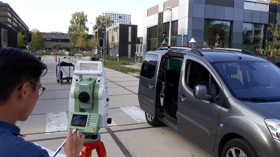
“Our fundamental problem with GPS is that it uses signals, in a rather limited bandwidth in the frequency domain,” said Christian Tiberius, an associate professor in the Geoscience and Remote Sensing department, at Delft and senior author of the paper “A hybrid optical-wireless network for decimetre-level terrestrial positioning,” which appeared in Nature in November 2022. “In built up environments, you have lots of buildings and other obstacles that reflect the radio signals. And then the GPS receiver actually receives the direct signal from the satellite, but added on top of that, all kinds of reflections.” Those reflections are copies of the same signal from the satellite, but slightly delayed.
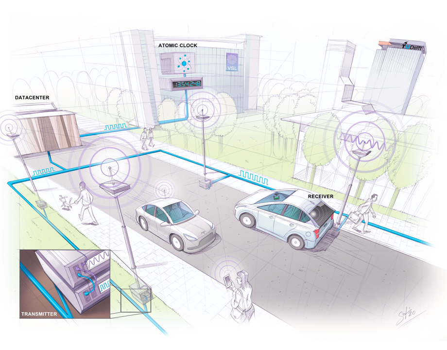 This illustration shows how timing signals carried by fiber optic cables would be broadcast to GPS receivers via transmitters mounted on lamp posts. Credit: Stephan Timmers
The solution to this problem is a matter of timing—very very precise timing. The idea came to Jeroen Koelemeij, an assistant professor at Amsterdam’s Vrije University, and first author of the Nature paper, after he had been working with Nobel Prize winner, David Wineland. Wineland had created a more precise atomic clock using lasers and single atoms. As Wineland has said, whenever history has produced a better clock, it’s improved its navigation.
This illustration shows how timing signals carried by fiber optic cables would be broadcast to GPS receivers via transmitters mounted on lamp posts. Credit: Stephan Timmers
The solution to this problem is a matter of timing—very very precise timing. The idea came to Jeroen Koelemeij, an assistant professor at Amsterdam’s Vrije University, and first author of the Nature paper, after he had been working with Nobel Prize winner, David Wineland. Wineland had created a more precise atomic clock using lasers and single atoms. As Wineland has said, whenever history has produced a better clock, it’s improved its navigation.
“I was thinking about this, and I realized, wait a minute, if we have very good clocks on Earth, that are much better than the traditional clocks, and also much better than the GPS clocks in space, why not distribute the time of that clock through the fiber optic network?” said Koelemeij. Doing so would basically transform a fiber optic network into a kind of distributed atomic clock available everywhere.
And that would allow us to rebuild the GPS system essentially from scratch, but, crucially, using the billions and billions of dollars in infrastructure that we’ve already constructed.
Become a Member: Join ASME
The system would not need an atomic clock at every transmitter—the time from just a few clocks would be shared over the network. Using the White Rabbit technique created by CERN for the Large Hadron Collider—already in use in other systems that require precise timing—a measurement of a round trip signal pulse from one clock would align the timing of the whole network like atomic clockwork. The White Rabbit protocol would synchronize every node on the network and easily negate any nanoseconds delays that might be caused by temperature driven expansion or contraction of fiber optic cables. A microsecond error, not uncommon with older techniques, results in a positioning error of 300 meters, as radio signals for navigation travel at the speed of light, nearly 300 million meters per second.
“We get that down to the point-one nanosecond/point-two nanosecond level,” said Koelemeij. “So, you’re talking, then, about errors of three to six centimeters just because of the timing.”
Reflective buildings are only part of what makes our current GPS systems inaccurate. When it first came on the scene GPS used a bandwidth that was wide enough for its purposes. “Times have changed,” said Tiberius. “This narrowband is actually why the signals start to overlap, and the receiver gets literally confused.” Current bandwidths mean the signal bits last for microseconds (“For a radio signal, this is forever, nearly,” said Tiberius). As a result, buildings and other obstacles turn urban environments into echo rooms with multiple overlapping signals. A phone or car might receive 50 copies of the same signal.
Learn More Uses for GPS: GPS Helps Robots Get the Job Done
The new system would operate in the 200- or 500-megahertz bandwidth, but without hogging the whole thing. There’s no need to transmit a stream with ones and zeros for data transfer. For ranging and positioning, the system transmits a signal which is known, a-priori, to the receiver.
“If you use, for instance, a very wide band, but use a tiny bit of 10-megahertz bandwidth at the left edge and 10 megahertz of bandwidth at the right edge, that’s actually enough for us to reconstruct the navigation signal,” said Tiberius. “So, we don’t need the full bandwidth to actually confirm that you receive the signal or measure the delay.”
Of course, there’s a lot that needs to happen before SuperGPS can tell us under which couch cushion we’ve lost our phone. The receiver prototype that Koelemeij and Tiberius built is shoebox-sized—pretty far away from fitting in a smartphone. And then there’s the issue of getting the world to sign up. Needless to say, standardization will be required, as will funding.
“I think you can sketch a very clear a clear business case. The GPS system is a system that costs the United States about one billion per year, but they earn billions per year by it, because it enables so many things, including mobile networks,” said Koelemeij. “So, you might say if you create a better navigation system, you will create tons of new apps and you will be able to make money with it.”
Michael Abrams is a science and technology writer in Westfield, N.J.
Now, thanks to researchers at Delft University of Technology and Vrije Universiteit Amsterdam, there’s a new type of GPS—what they call “SuperGPS”— that’s accurate to within 10 centimeters.
The big reason GPS puts you on one side of the street when you’re really on the other, is that its signals bounce off the big reflecting surfaces that are the buildings of our urban habitats.
“Our fundamental problem with GPS is that it uses signals, in a rather limited bandwidth in the frequency domain,” said Christian Tiberius, an associate professor in the Geoscience and Remote Sensing department, at Delft and senior author of the paper “A hybrid optical-wireless network for decimetre-level terrestrial positioning,” which appeared in Nature in November 2022. “In built up environments, you have lots of buildings and other obstacles that reflect the radio signals. And then the GPS receiver actually receives the direct signal from the satellite, but added on top of that, all kinds of reflections.” Those reflections are copies of the same signal from the satellite, but slightly delayed.
This illustration shows how timing signals carried by fiber optic cables would be broadcast to GPS receivers via transmitters mounted on lamp posts. Credit: Stephan Timmers
“I was thinking about this, and I realized, wait a minute, if we have very good clocks on Earth, that are much better than the traditional clocks, and also much better than the GPS clocks in space, why not distribute the time of that clock through the fiber optic network?” said Koelemeij. Doing so would basically transform a fiber optic network into a kind of distributed atomic clock available everywhere.
And that would allow us to rebuild the GPS system essentially from scratch, but, crucially, using the billions and billions of dollars in infrastructure that we’ve already constructed.
Become a Member: Join ASME
The system would not need an atomic clock at every transmitter—the time from just a few clocks would be shared over the network. Using the White Rabbit technique created by CERN for the Large Hadron Collider—already in use in other systems that require precise timing—a measurement of a round trip signal pulse from one clock would align the timing of the whole network like atomic clockwork. The White Rabbit protocol would synchronize every node on the network and easily negate any nanoseconds delays that might be caused by temperature driven expansion or contraction of fiber optic cables. A microsecond error, not uncommon with older techniques, results in a positioning error of 300 meters, as radio signals for navigation travel at the speed of light, nearly 300 million meters per second.
“We get that down to the point-one nanosecond/point-two nanosecond level,” said Koelemeij. “So, you’re talking, then, about errors of three to six centimeters just because of the timing.”
Reflective buildings are only part of what makes our current GPS systems inaccurate. When it first came on the scene GPS used a bandwidth that was wide enough for its purposes. “Times have changed,” said Tiberius. “This narrowband is actually why the signals start to overlap, and the receiver gets literally confused.” Current bandwidths mean the signal bits last for microseconds (“For a radio signal, this is forever, nearly,” said Tiberius). As a result, buildings and other obstacles turn urban environments into echo rooms with multiple overlapping signals. A phone or car might receive 50 copies of the same signal.
Learn More Uses for GPS: GPS Helps Robots Get the Job Done
The new system would operate in the 200- or 500-megahertz bandwidth, but without hogging the whole thing. There’s no need to transmit a stream with ones and zeros for data transfer. For ranging and positioning, the system transmits a signal which is known, a-priori, to the receiver.
“If you use, for instance, a very wide band, but use a tiny bit of 10-megahertz bandwidth at the left edge and 10 megahertz of bandwidth at the right edge, that’s actually enough for us to reconstruct the navigation signal,” said Tiberius. “So, we don’t need the full bandwidth to actually confirm that you receive the signal or measure the delay.”
Of course, there’s a lot that needs to happen before SuperGPS can tell us under which couch cushion we’ve lost our phone. The receiver prototype that Koelemeij and Tiberius built is shoebox-sized—pretty far away from fitting in a smartphone. And then there’s the issue of getting the world to sign up. Needless to say, standardization will be required, as will funding.
“I think you can sketch a very clear a clear business case. The GPS system is a system that costs the United States about one billion per year, but they earn billions per year by it, because it enables so many things, including mobile networks,” said Koelemeij. “So, you might say if you create a better navigation system, you will create tons of new apps and you will be able to make money with it.”
Michael Abrams is a science and technology writer in Westfield, N.J.
Related Content
Wearable Patch Offers Voice to the Voiceless
Apr 18, 2024
A thin self-powered patch can sense the movement of laryngeal muscles and translate those movements into audible speech.

Energy Blog: Noticeable Eclipse Impact on Electricity Sector
Apr 17, 2024

Breakthrough Could Make for Long-Range EVs
Apr 16, 2024
A simple method could lead to electric vehicles that can go much father on a single charge, and batteries that last years longer than present technology.

Aircraft Carriers May Get Advanced Hoist
Apr 15, 2024
To streamline operations and improve performance, the U.S. Navy commissioned a new hoist to raise and lower the aircraft elevators.